Amelia Island avoids overdevelopment because its physical geography, ecological sensitivity, and local regulatory framework collectively impose hard limits on growth that no single developer or policy can override. The island's 13-mile barrier island footprint, its salt marsh ecosystems, and the constrained road network along Sadler Road and A1A create natural capacity ceilings that Fernandina Beach city codes and Nassau County zoning rules reinforce through strict land-use standards. Tourist Development Tax collections reached just under $12 million in FY 2025, with growth slowing to 3.9%, a clear signal that the island is approaching its physical tourism ceiling. The result is a place where heritage, nature, and community character remain intact, not by accident, but by the convergence of geography and governance.
Why Amelia Island avoids overdevelopment: natural constraints
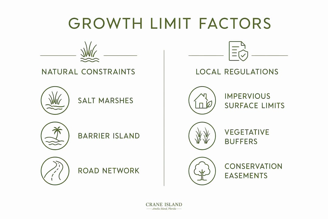
The most honest answer to why Amelia Island avoids overdevelopment starts with the land itself. Physical capacity, not political will alone, is the primary governor of growth here. Practitioners who study coastal development recognize that constrained road networks and sensitive ecosystems naturally cap growth more reliably than any zoning ordinance written on paper.
The road network as a natural ceiling
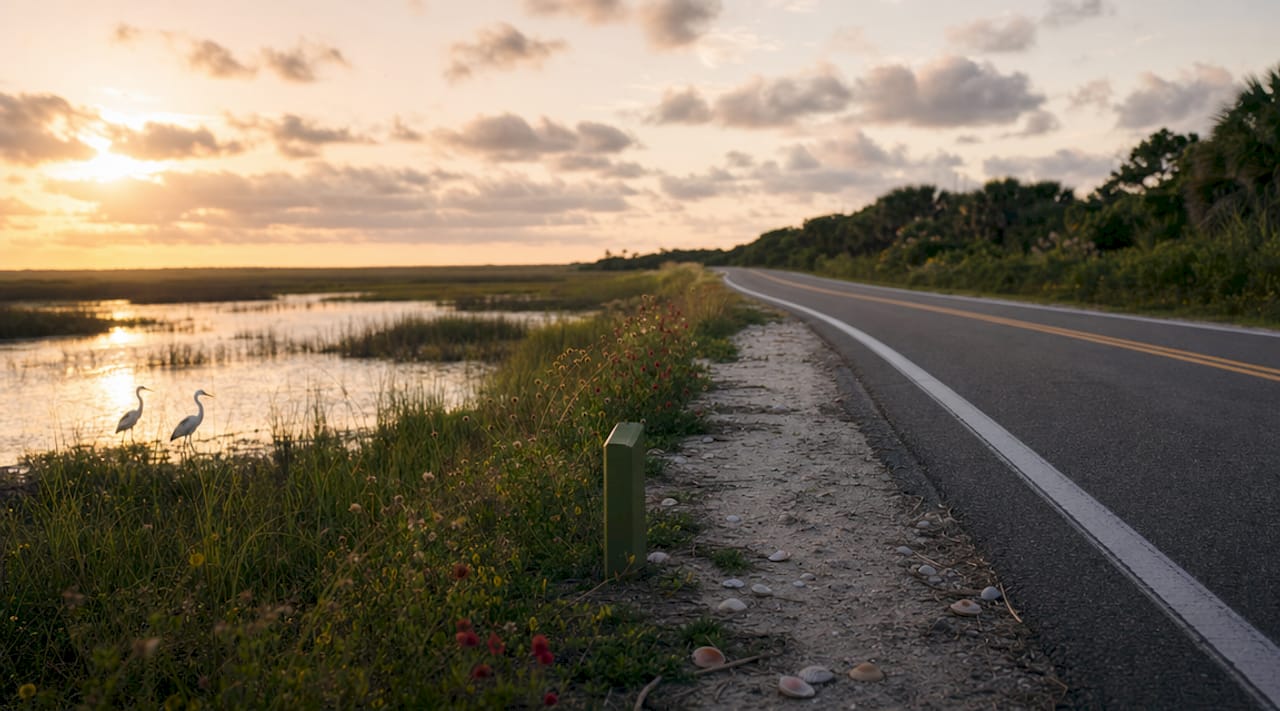
Sadler Road and A1A are the island's two primary access corridors, and both are hemmed in by wetlands and existing development that make widening them structurally impractical. Peak-season congestion now occurs on most days, and expansion options are extremely limited due to the island's geography. When the roads are full, the island is full. That is a physical truth no planning document can rewrite.
Salt marshes as ecological guardians
The salt marsh ecosystem surrounding Amelia Island does more than frame a beautiful view. Salt marshes absorb storm surge, filter toxins from runoff, and serve as nursery habitats for commercially important fish species. Developing into or adjacent to these marshes does not just damage the environment. It removes the very infrastructure that protects existing homes and communities from flooding. Any builder who ignores that reality faces not only regulatory resistance but also the physics of a coastline that will push back.
The finite footprint of a barrier island
At 13 miles long, Amelia Island has a fixed landmass. There is no annexing additional acreage the way an inland city might expand outward. This finite boundary means every new structure competes directly with existing natural and residential land. The island's unique real estate character is shaped in large part by this scarcity, which keeps density low and quality high.
Pro Tip: If you are evaluating coastal properties, always ask about the percentage of a parcel that sits within wetland buffer zones. On Amelia Island, that number directly determines what can and cannot be built.
How do local policies and regulations control growth?
Natural constraints set the ceiling, but Fernandina Beach and Nassau County policies define the walls. The regulatory environment here is more protective than most Florida coastal communities, and the differences are measurable.
Fernandina Beach versus Nassau County standards
Fernandina Beach city code limits impervious surface coverage to 60% for commercial projects and requires a 15-foot vegetative buffer, while Nassau County allows 70% impervious coverage. That 10-point difference translates directly into more green space, better stormwater absorption, and smaller building footprints within city limits. For families considering coastal home ownership, these standards mean the neighborhood around your property is legally protected from the kind of wall-to-wall paving that degrades other coastal communities.
| Regulatory standard | Fernandina Beach | Nassau County |
|---|---|---|
| Impervious surface limit (commercial) | 60% | 70% |
| Vegetative buffer requirement | 15 feet | Less restrictive |
| Conservation easement use | Active (St. Mary's Farm) | County-level programs |
| Comprehensive plan enforcement | City code | County zoning |
Conservation easements as permanent protection
Nassau County paid $2.1 million for the St. Mary's Farm easement, a 599.9-acre agreement that permanently prevents commercial development while protecting water quality and rare habitats. Conservation easements are increasingly favored in local strategic land-use planning because they protect critical habitats while minimizing ongoing taxpayer burden. Once recorded, an easement runs with the land regardless of who owns it, making it one of the most durable tools in the preservation toolkit.
Community resistance as a regulatory force
When the Riverstone project proposed 11 mid-rise towers on Amelia Island, residents organized sustained opposition based on traffic impact, ecological harm, and incompatibility with the island's low-density character. That resistance reflects a community culture that treats the island's Amelia Island development policies as a shared civic responsibility, not just a bureaucratic function. Organized opposition has repeatedly shaped outcomes here in ways that formal zoning alone cannot guarantee.
Pro Tip: Before purchasing on Amelia Island, review Nassau County's comprehensive plan and any active conservation easements adjacent to your target parcel. These documents reveal what your neighbors can and cannot build for decades to come.
What impacts does controlled development have on community and lifestyle?
Controlled growth produces real benefits, but it also creates genuine tensions that any family considering relocation should understand clearly.
- Quality-of-life preservation. Residents and visitors consistently cite the absence of high-rise towers, strip malls, and overcrowded beaches as the defining feature of life on Amelia Island. That character is a direct product of the density limits and buffer requirements described above.
- Traffic congestion as a trade-off. The same road constraints that prevent overdevelopment also mean that peak-season traffic on Sadler Road and A1A can test your patience. The island's workforce housing shortage compounds this, as service workers commute from the mainland because affordable housing on the island is scarce.
- Workforce housing pressure. Restrained development combined with rising visitor demand has produced a housing affordability gap. Workers in hospitality, healthcare, and retail often cannot afford to live where they work, which creates commuting patterns that add to road congestion and strain community cohesion.
- Seasonal versus year-round balance. The island's tourism model now emphasizes longer-stay, higher-spending visitors rather than volume growth, with paid parking introduced as a management tool. This quality-over-quantity approach protects the experience for year-round residents while keeping the economic engine running without overwhelming finite infrastructure.
- Property value stability. Scarcity of developable land, combined with strong environmental protections, supports long-term property values. Buyers who understand the island's regulatory framework recognize that the same rules protecting the marsh view outside their window also protect their investment.
What conservation initiatives support sustainable growth?
Preservation on Amelia Island is not passive. Active programs and public investments reinforce the natural and regulatory limits already in place.
Nassau County's acquisition of Piney Island opened new public recreational access while permanently removing the parcel from development consideration. Salt marsh restoration efforts along the island's western edge rebuild ecological buffers that decades of adjacent development had degraded. Programs like CLAM (Conservation Land Acquisition and Management) provide a strategic framework for identifying, prioritizing, and funding land protection before development pressure arrives rather than after.
Key conservation efforts currently active on and around Amelia Island include:
- Piney Island acquisition: County purchase providing public access and permanent habitat protection
- St. Mary's Farm easement: 599.9 acres permanently protected for water quality and rare species habitat
- Salt marsh restoration: Active ecological work rebuilding storm surge absorption and marine nursery capacity
- CLAM program: Strategic land acquisition framework targeting parcels with the highest ecological and community value
- Tourist Development Tax reinvestment: Revenue directed toward infrastructure maintenance rather than capacity expansion
Each of these efforts reinforces the others. Protecting marshland reduces flood risk for existing homes. Reducing flood risk makes those homes more insurable and more valuable. More valuable homes generate more tax revenue that can fund further conservation. The cycle is self-reinforcing when managed thoughtfully.
How does Amelia Island compare to overdeveloped coastal areas?
The contrast between Amelia Island and rapidly developed coastal communities elsewhere in Florida and along the Southeast coast is instructive. Coastal cities that filled in marshlands to accommodate growth now face catastrophic storm damage and environmental degradation that costs far more to remediate than the development revenue ever generated.
| Factor | Amelia Island | High-density coastal developments |
|---|---|---|
| Marsh preservation | Active, regulatory, and easement-protected | Often sacrificed for buildable land |
| Road infrastructure | Constrained, limits growth naturally | Expanded to accommodate density |
| Tourism model | Quality over quantity, longer stays | Volume-driven, high turnover |
| Flood risk trajectory | Managed through preservation | Increasing as natural buffers are removed |
| Community character | Intact, low-density, historically grounded | Often homogenized by rapid construction |
The lesson from overdeveloped coastal areas is not that growth is inherently bad. It is that growth without physical and regulatory limits destroys the very qualities that made a place worth visiting or living in. Amelia Island's approach, shaped as much by geography as by governance, offers a model that other barrier islands and coastal communities are beginning to study seriously. For families evaluating Amelia Island for relocation, this comparative context matters. You are not just buying a home. You are buying into a planning philosophy with a demonstrated track record.
Key takeaways
Amelia Island avoids overdevelopment because physical geography, ecological sensitivity, and layered local regulations work together to impose hard limits that protect community character and long-term property values.
| Point | Details |
|---|---|
| Natural capacity limits | Sadler Road, A1A, and salt marsh ecosystems physically cap growth more reliably than zoning alone. |
| Regulatory reinforcement | Fernandina Beach's 60% impervious surface limit and 15-foot buffer requirement directly restrict development footprints. |
| Conservation easements | The St. Mary's Farm agreement permanently protects 599.9 acres, removing it from development consideration at a cost of $2.1 million. |
| Quality-over-quantity tourism | Slowing Tourist Development Tax growth signals a natural tourism plateau, reinforcing a strategy focused on higher-spending visitors. |
| Community activism | Organized resident opposition to projects like Riverstone demonstrates that community culture functions as a practical regulatory force. |
What I've learned watching Amelia Island hold its ground
I have spent years watching coastal communities make the same mistake: they treat development capacity as a problem to be solved rather than a limit to be respected. Amelia Island is different, and not entirely by design. The marshes, the two-lane roads, and the finite shoreline did most of the work before any planner wrote a single ordinance.
What strikes me most is how the physical constraints and the community values have grown to reinforce each other over time. Residents who moved here for the quiet, the marsh views, and the historic character of Fernandina Beach become the same residents who show up at planning meetings to oppose the next Riverstone. The land shapes the people, and the people protect the land.
That said, I watch a few indicators closely. Workforce housing pressure is the most underappreciated risk here. When the people who staff the restaurants, maintain the homes, and care for the elderly cannot afford to live on the island, the community begins to hollow out in ways that no zoning code addresses. The island's construction financing environment has also shifted, with higher rates causing builders to reconsider project scale and feasibility, which inadvertently supports the low-density character that residents value.
For families considering a move here, my honest advice is this: the protections are real, but they require ongoing civic engagement to remain real. Attend a Nassau County planning meeting. Read the comprehensive plan. Know what is proposed for the parcels near any home you are considering. The island's character is worth protecting, and that protection is a shared responsibility.
— John Hillman
Experience Amelia Island's preservation ethic firsthand with Crane Island
Craneisland was built on the same principles that make Amelia Island worth protecting. With only 14 custom homesites woven into preserved marshlands and forests along the Intracoastal Waterway, Crane Island reflects the island's commitment to placing homes within the land rather than over it. Every homesite honors the vegetative buffers, the marsh views, and the Lowcountry architectural heritage that define this place.
If you are drawn to a community where the porch is a true living room and your neighbors share a genuine reverence for the natural world around them, explore the available homesites at Crane Island. You can also learn more about the design and build process and how each home is crafted to honor both your personal story and the island's legacy.
FAQ
Why does Amelia Island have limited development compared to other Florida islands?
Amelia Island's 13-mile barrier island footprint, salt marsh ecosystems, and two-lane road network create physical capacity limits that restrict intensive development. Fernandina Beach and Nassau County regulations reinforce these natural constraints through impervious surface limits and buffer zone requirements.
What specific policies prevent overdevelopment on Amelia Island?
Fernandina Beach city code limits commercial impervious surface coverage to 60% and requires a 15-foot vegetative buffer, stricter than Nassau County's 70% allowance. Conservation easements like the 599.9-acre St. Mary's Farm agreement permanently remove key parcels from development consideration.
How do salt marshes protect Amelia Island from overdevelopment?
Salt marshes absorb storm surge, filter water toxins, and support marine nursery habitats, making them ecologically irreplaceable. Developing into or adjacent to these areas removes natural flood protection, which creates regulatory and practical barriers to expansion.
Does controlled development affect property values on Amelia Island?
Scarcity of developable land combined with strong environmental protections supports long-term property value stability. The same regulations that limit new construction also protect the natural character and low-density environment that make existing properties desirable.
What is the biggest challenge created by Amelia Island's growth limits?
Workforce housing is the most significant tension produced by controlled development. Rising visitor demand and limited affordable housing stock force service workers to commute from the mainland, adding to road congestion and straining community infrastructure.