
Conservation development is a land-use approach that clusters homes or other built uses onto a portion of a site while permanently protecting the remainder as managed open space. The protected share typically runs 40%–70% of buildable acreage, with 50% serving as a widely used working benchmark. The primary legal instrument is a conservation easement held by a qualified land trust or government entity, and every project that expects its open space to remain ecologically healthy needs a funded, permanent stewardship mechanism from day one.
If you are a landowner or planner weighing whether this approach fits your situation, three things matter immediately:
- Open space target: plan for at least 40%–50% of buildable land to be permanently protected; some model ordinances and state programs require more.
- Legal protection: a conservation easement is the standard tool; it runs with the land, survives ownership changes, and is monitored by the easement holder.
- Stewardship funding: preserved land without an active management plan and a dedicated funding source tends to degrade over time, eroding both ecological and property value.
Key Takeaways
| Point | Details |
|---|---|
| Open-space target | Model ordinances call for 40%–70% of buildable acreage as protected open space; 50% is a common working benchmark. |
| Primary legal tool | A conservation easement, held by an accredited land trust or government entity, provides permanent, binding protection that runs with the land. |
| Stewardship is non-optional | Preserved land without active management and dedicated funding degrades over time, reducing both ecological and property value. |
| Price premium potential | Homes adjacent to well-managed open space have commanded a 20%–30% premium in documented cases, contingent on visible stewardship quality. |
| Craneisland | Crane Island on Amelia Island applies these principles through preserved marshlands, 14 limited homesites, and community stewardship built into its governance. |
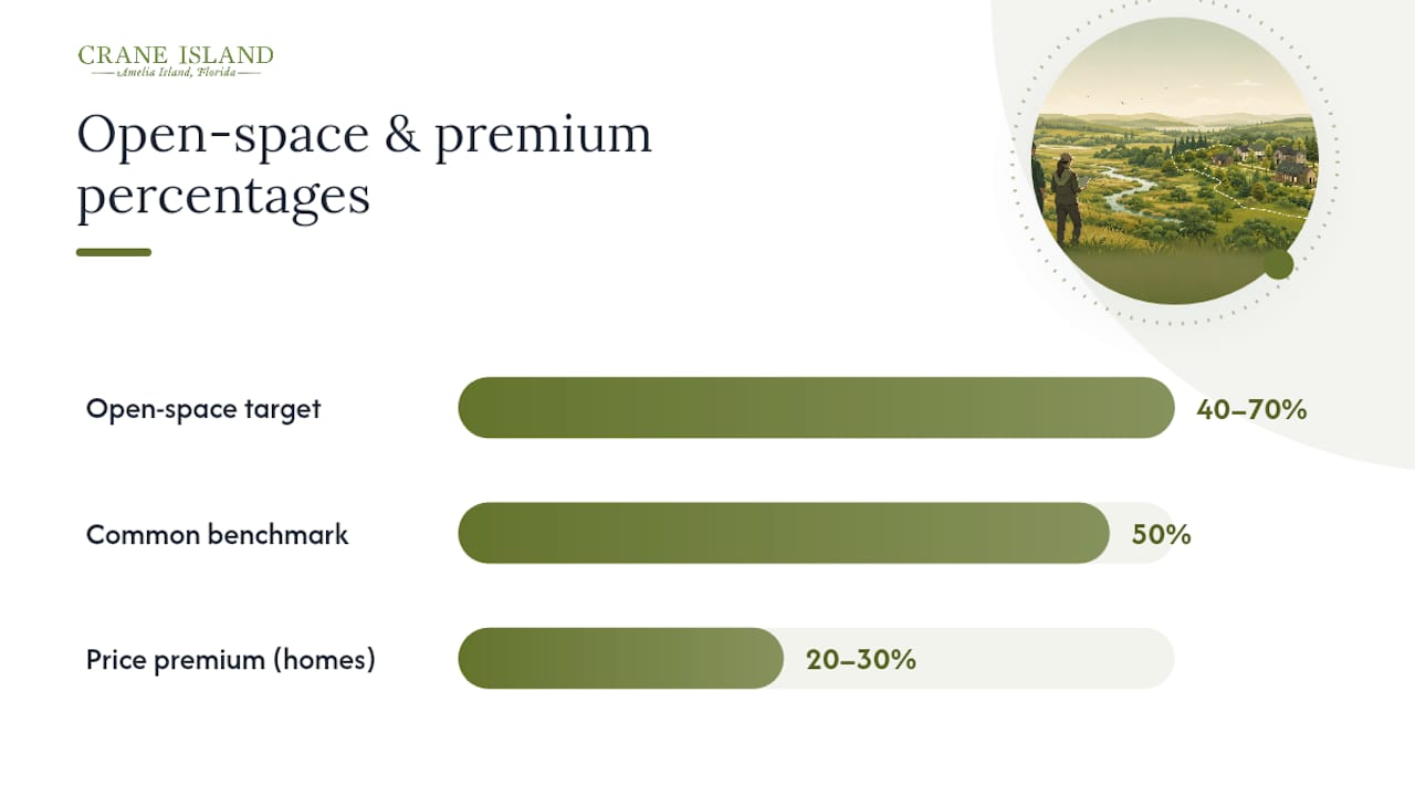
Table of Contents
- What conservation development actually tries to achieve
- Common types of conservation development you will encounter
- Design features that shape a conservation development on the ground
- Legal tools and policy mechanisms used in the U.S.
- Benefits and trade-offs worth weighing honestly
- How to implement a conservation development, step by step
- Financing options and long-term stewardship arrangements
- U.S. case studies that show what outcomes look like
- Typical timelines, scale targets, and cost drivers
- Why developers and communities choose this approach
- Crane Island brings conservation development principles to life
- Sources
- FAQ
What conservation development actually tries to achieve
Conservation development aligns development density with conservation priorities rather than treating them as opposing forces. The central idea is that a site's most ecologically significant areas — wetlands, mature forest, wildlife corridors, floodplains — should drive where buildings go, not the other way around.
Four planning principles define the approach in practice. First, cluster development concentrates homes or commercial uses on the least sensitive portion of a parcel, leaving primary conservation areas intact. Second, natural features become community amenities: a preserved marsh, a meadow trail, or a forested buffer adds more lasting value than a manicured lawn when it is well managed and visible from homes. Third, density neutrality means the total number of units permitted under conventional zoning is often preserved, just redistributed onto a smaller footprint. Fourth, the design explicitly accounts for ecological connectivity, so preserved areas link to adjacent conservation lands rather than sitting as isolated fragments.
The goals extend beyond habitat. Water quality improves when development avoids riparian buffers and uses permeable surfaces and low-impact stormwater management. Scenic values and community character are protected because the most visible natural features stay intact. Biodiversity preservation follows from reducing fragmentation, which is one of the primary drivers of species loss in developed landscapes.
Pro Tip: Commission an ecological survey before any design work begins. Identifying primary conservation areas — wetlands, rare plant communities, wildlife movement corridors — early in the process prevents costly redesigns and positions the project favorably with local planning officials and potential easement holders.
Common types of conservation development you will encounter
The term "conservation development" covers several distinct models. Knowing which type fits your situation depends on scale, funding, and who is leading the project.
Conservation subdivision. The most common form in U.S. residential development. Lots are clustered on a portion of the parcel; the remainder is set aside as permanently protected open space, typically through a conservation easement or deed restriction. Works well for parcels of 50 acres or more where the developer wants to sell individual lots or homes.
Conservation buyer / conservation limited development project (CLDP). A land trust or conservation buyer purchases a property and sells off a limited number of development rights to fund the conservation of the remainder. The development component is intentionally modest, sized to generate enough revenue to cover the conservation transaction and stewardship endowment without compromising the primary conservation objective.
- Best fit: large, high-conservation-value parcels where outright purchase is not feasible.
- Lead actor: typically a land trust partnering with a private developer or conservation-minded buyer.
Limited development. Similar to a CLDP but often simpler: a small number of lots or a single homesite is carved out of a larger parcel to fund its conservation. The development component is secondary; conservation is the primary goal from the start.
Conservation-oriented planned development. A larger-scale, mixed-use or residential planned unit development (PUD) that incorporates significant open-space set-asides, ecological design standards, and stewardship requirements into its entitlement documents. Requires more complex zoning negotiations but can accommodate higher unit counts and a broader range of uses.
Conservation community. A branded residential community where the conservation mission is central to the marketing and governance structure. Stewardship is typically managed through a homeowners association (HOA) with explicit ecological bylaws, and the preserved open space is a primary amenity. Crane Island on Amelia Island is a working example of this model, where preserved marshlands and a limited number of homesites define the community's character and long-term value.
Design features that shape a conservation development on the ground
Good conservation development uses ecological mapping to drive every siting decision, not just the location of the open-space boundary. The layout of roads, lots, stormwater infrastructure, and trails all follow from where the ecologically sensitive areas are, not from a conventional grid imposed on the land.
Site assessment checklist
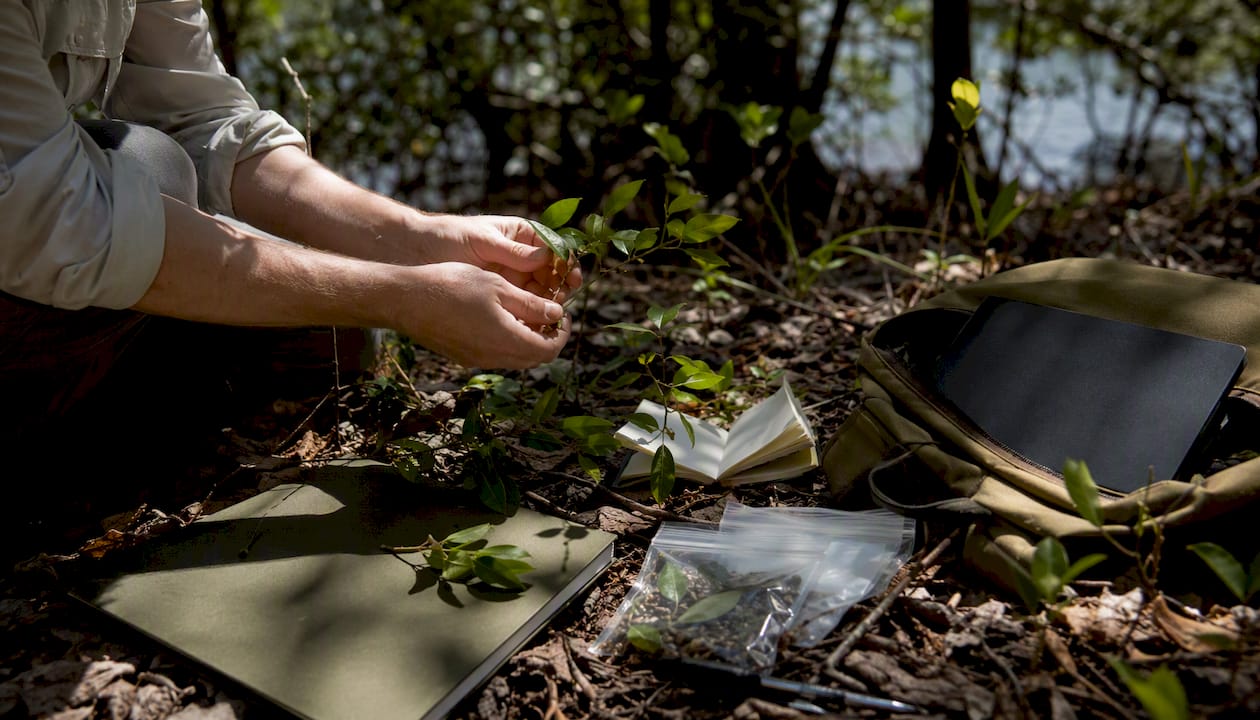
Before a concept plan is drawn, a thorough site assessment should cover:
- Ecological survey: vegetation communities, rare species, wildlife movement corridors
- Hydrology: floodplains, wetlands, seasonal drainage patterns, recharge areas
- Soils: prime farmland, hydric soils, erosion-prone areas
- Cultural resources: historic structures, archaeological sites, traditional land uses
- Viewsheds: prominent natural features visible from roads or adjacent properties
- Agricultural value: productive soils or active agricultural uses worth preserving
Design checklist
Once primary conservation areas are mapped, the design phase translates that map into a buildable layout:
- Cluster lots on the least sensitive portion of the parcel
- Use narrow roads and shared driveways to reduce impervious cover
- Apply permeable paving in parking areas and low-traffic roads
- Route stormwater through vegetated swales, rain gardens, and bioretention cells rather than conventional pipes
- Align trails and viewpoints to connect residents to the preserved open space
- Design habitat corridors wide enough to support wildlife movement between preserved areas and adjacent conservation lands
- Use sustainable landscaping practices in common areas and encourage native plantings on private lots
NRCS conservation practice standards and local technical guides provide the scientific and design specifications used to plan and implement vegetative, soil, and water conservation measures within development projects. For example, NRCS Conservation Cover (Code 327) specifies criteria for establishing permanent vegetative cover that protects soil, filters runoff, and supports habitat.
Design targets drawn from model ordinances
Communicating these priorities to stakeholders works best through layered maps: start with the ecological constraints layer (wetlands, floodplains, steep slopes), overlay the primary conservation areas, then show the development envelope that remains. That sequence makes the logic visible and builds consensus before lot lines are drawn.
Legal tools and policy mechanisms used in the U.S.
The conservation easement is the foundational legal instrument in U.S. conservation development. It is a voluntary, legally binding agreement between a landowner and a qualified easement holder — typically an accredited land trust or a government agency — that restricts certain uses of the land in perpetuity. The easement runs with the land, meaning it binds all future owners. The landowner retains title and can sell or pass on the property; the easement holder monitors compliance and enforces the restrictions.
Complementary instruments and policy tools include:
- Deed restrictions and covenants: recorded in the property deed, these restrict uses on individual lots or common areas and are enforceable by the HOA or a designated third party.
- HOA ecological bylaws: in conservation communities, the HOA governing documents specify maintenance standards for open space, native plantings, and stormwater infrastructure.
- Fee-simple protection: in some projects, the land trust acquires the open-space parcel outright rather than holding an easement, providing the strongest form of protection.
- Density bonuses: local zoning codes may allow a developer to build more units than the base zoning permits in exchange for permanently protecting a specified share of the site.
- Transfer of development rights (TDR): a landowner in a designated sending zone sells development rights to a buyer in a receiving zone, concentrating growth while protecting the sending-zone land.
- Model conservation subdivision ordinances: these provide local governments with ready-made zoning language that establishes open-space minimums, design standards, and stewardship requirements. Flexible local zoning is a key enabler of conservation development, and model ordinances are the fastest path to that flexibility.
Pro Tip: Before submitting a concept plan, meet with local planning staff to identify whether your jurisdiction has an explicit conservation subdivision pathway. Some states and counties have model ordinance language already on the books; finding it early avoids costly variances and redesigns later.
For technical design standards, the NRCS conservation practice standards and the Land Trust Alliance provide the most authoritative guidance in the U.S. State-specific model ordinances are often available through state planning associations or land trust coalitions. Every project should involve local legal counsel for title review and easement drafting; the Land Trust Alliance's accreditation standards are a useful benchmark for evaluating a prospective easement holder.
Benefits and trade-offs worth weighing honestly
Conservation development often delivers a net positive for biodiversity, water quality, and long-term municipal costs, but it carries real trade-offs in upfront complexity and stewardship burden. Understanding both sides clearly is what separates projects that endure from those that disappoint.
Environmental benefits
Habitat protection is the most direct benefit. By permanently removing the most ecologically sensitive areas from development, a well-designed project reduces habitat fragmentation, one of the primary drivers of biodiversity loss in the eastern United States. Water quality improves through riparian buffers, reduced impervious cover, and low-impact stormwater management. A synthesis estimated conservation development has protected roughly 4 million hectares in the U.S. and accounts for a substantial share of private-land conservation activity, though outcomes vary considerably by project design and stewardship quality.
Economic and community benefits
- Homes adjacent to high-quality managed open space can command a price premium. The Ruckelshaus Institute reports that in well-managed conservation communities such as Prairie Crossing, that premium has reached 20%–30% in some cases, though the premium depends on visible stewardship and well-designed amenities.
- Municipalities often see lower long-term infrastructure costs: clustered development requires less road length, fewer utility extensions, and reduced stormwater management compared to conventional sprawl.
- Natural features used as community amenities — trails, preserved forests, marsh views — tend to hold their appeal across market cycles in ways that built amenities do not.
- Environmental sustainability in real estate has become a meaningful driver of buyer preference, particularly in coastal and exurban markets.
Trade-offs and honest criticisms
- Upfront cost and complexity: ecological surveys, easement legal work, and stewardship endowment funding add costs that conventional subdivisions avoid. These are real and should be budgeted from the start.
- Affordability: clustering lots on a smaller footprint can increase per-lot land costs, which tends to push conservation communities toward the higher end of the market.
- Stewardship burden: preserved land without active management can be invaded by non-native species, reducing ecological and property value over time. This is not a theoretical risk; it is a documented failure mode.
- Regulatory barriers: in jurisdictions without model conservation subdivision ordinances, developers may face resistance from planning staff unfamiliar with clustered layouts or narrow road widths.
- Automobile dependence: many conservation subdivisions are sited in exurban locations where residents depend on cars for daily needs, which limits their sustainability credentials beyond the parcel boundary.
How to implement a conservation development, step by step
The implementation arc runs from site assessment through design, legal protection, permitting, construction, and long-term stewardship. Each phase has its own decision points and stakeholder roles.
Step-by-step sequence
- Commission an ecological site assessment. Hire a qualified ecologist to map wetlands, rare species, hydrology, soils, and wildlife corridors. This report becomes the foundation for all subsequent decisions and is typically required by easement holders and permitting agencies.
- Identify primary and secondary conservation areas. Using the ecological assessment, designate which portions of the site are non-negotiable for protection (primary) and which offer flexibility (secondary). Primary areas drive the development envelope.
- Develop a concept plan. Work with a landscape architect or conservation planner to sketch the clustered development footprint, open-space boundaries, road layout, and trail network. Share this with local planning staff early.
- Engage the community and stakeholders. Present the concept to neighbors, local government, and potential easement holders. Early engagement surfaces concerns before they become legal objections.
- Negotiate zoning and permits. Apply for any necessary variances, PUD approvals, or conservation subdivision designations. ULI research documents practical lessons for public-private partnerships and integrating economic development with environmental protection at this stage.
- Draft and record the conservation easement. Work with an accredited land trust and local legal counsel to draft the easement, conduct a baseline ecological report, and record the document with the county.
- Establish stewardship funding. Set up a stewardship endowment, HOA reserve fund, or other dedicated funding mechanism before construction begins. The easement holder will typically require evidence of adequate funding.
- Complete construction. Build to the approved plans, with inspection checkpoints to confirm that conservation area boundaries, stormwater infrastructure, and road widths meet the approved design.
- Transfer stewardship responsibilities. Hand off ongoing monitoring and management to the designated steward — land trust, HOA with ecological bylaws, or a professional ecological manager — with a written stewardship plan and funding in place.
Roles and responsibilities
- Landowner/developer: initiates the project, funds the ecological survey and easement legal work, and establishes the stewardship endowment.
- Land trust: holds and monitors the conservation easement, conducts annual monitoring visits, and enforces restrictions.
- Local government: reviews and approves the concept plan, zoning applications, and subdivision plat; may provide density bonuses or TDR credits.
- HOA: manages common open space, enforces deed restrictions on individual lots, and funds ongoing maintenance.
- Ecological manager: conducts active habitat management — invasive species control, prescribed burns, native plantings — on a contracted or staff basis.
Key documents checklist
- Baseline ecological report (required for easement recording)
- Conservation easement document (recorded with county)
- Stewardship plan (management objectives, tasks, schedule)
- Stewardship endowment or funding agreement
- HOA governing documents with ecological bylaws
- Subdivision plat and approved site plan
Financing options and long-term stewardship arrangements
Financing a conservation development is almost always a mixed approach. Real-estate proceeds from lot or home sales fund a portion of the conservation work; grants, tax incentives, and stewardship fees cover the rest. No single funding source is sufficient on its own for most projects.
Common financing models
- Conservation buyer / limited development proceeds: the sale of a small number of lots or homes generates the revenue needed to fund the conservation transaction and stewardship endowment. This is the most common model for land-trust-led projects.
- Developer-funded stewardship endowment: the developer capitalizes a dedicated endowment at closing, sized to generate enough annual income to cover ongoing monitoring, management, and easement enforcement. Endowment sizing is typically negotiated with the easement holder and depends on the complexity and acreage of the conservation area.
- Public grants: federal and state conservation programs provide grants for land protection, habitat restoration, and stewardship. The NRCS's Environmental Quality Incentives Program (EQIP) and the Agricultural Conservation Easement Program (ACEP) are two of the most accessible federal sources for private landowners.
- Tax incentives: a donated conservation easement may qualify as a charitable contribution deduction under federal tax law, providing a significant financial incentive for landowners who donate rather than sell their development rights. State-level tax credit programs exist in several states and can substantially improve project economics.
- HOA stewardship fees: in conservation communities, annual HOA dues include a dedicated allocation for open-space management, invasive species control, and trail maintenance.
Where to look for federal and state assistance
- NRCS conservation practice standards and local Field Office Technical Guides provide both design specifications and access to cost-share programs.
- The Land Trust Alliance maintains a directory of accredited land trusts by state and provides guidance on easement structuring and stewardship fund sizing.
- State wildlife agencies and departments of natural resources often administer state-funded conservation easement programs and habitat restoration grants.
- The USDA Farm Service Agency (FSA) administers the Conservation Reserve Program (CRP), which can fund vegetative cover establishment on agricultural lands within or adjacent to a conservation development.
For land stewardship communities, the stewardship funding structure is often the most consequential long-term decision a developer makes. An underfunded endowment is one of the most common reasons preserved open space degrades within a decade of project completion.
U.S. case studies that show what outcomes look like
Case studies matter because they translate planning principles into measurable outcomes and governance choices. The gap between a well-designed project and a poorly stewarded one shows up most clearly in the evidence from real communities.
Prairie Crossing, Grayslake, Illinois
Prairie Crossing is one of the most studied conservation communities in the United States. Restored native vegetation supports a documented diversity of bird and mammal species, and the community's stormwater system — centered on a constructed wetland — has demonstrated measurable water-quality improvements compared to conventional development. Homes adjacent to the managed open space have commanded a price premium reported in some cases at 20%–30%, though that premium tracks closely with the quality and visibility of ongoing stewardship.
Conservation development at scale: national evidence
A peer-reviewed synthesis published in Conservation Biology compiled data on approximately 3,884 projects covering roughly 1.38 million hectares in a compiled dataset and estimated that conservation development projects protect roughly 4 million hectares across the U.S. when extrapolated. That scale positions conservation development as a meaningful complement to public land protection, particularly on private lands where outright purchase is not feasible.
Crane Island, Amelia Island, Florida
Crane Island on Amelia Island applies conservation development principles within a luxury coastal context. The community preserves surrounding marshlands and maritime forest as permanent open space, limits the total number of homesites to 14, and integrates stewardship of the natural environment into the community's governance and design. Lowcountry architecture is woven into the land rather than imposed on it, and residents have direct access to the Intracoastal Waterway and the preserved natural surroundings that define the island's character. For buyers interested in conservation communities in Florida, Crane Island represents one of the most deliberate applications of these principles in the coastal Southeast.
Pro Tip: When evaluating any conservation community, ask to see the stewardship plan and the endowment balance. A community that cannot produce both is carrying a long-term ecological and financial risk that will eventually affect property values.
Lessons from the cases
- Stewardship is the ongoing challenge, not the initial design. Projects that fund management adequately from the start consistently outperform those that treat stewardship as an afterthought.
- Early legal frameworks matter. Prairie Crossing's success depended on recording conservation easements before the first lot was sold, not after.
- Visible, well-managed open space drives the price premium. Degraded or invasive-dominated open space erodes it.
Typical timelines, scale targets, and cost drivers
A conservation development project typically runs two to five years from initial site assessment to first home occupancy, with the legal protection and permitting phases often accounting for the longest delays. Large or complex projects with multiple easement holders, state permits, or significant restoration requirements can run longer.
Common open-space targets
Model ordinances and practitioner guides commonly call for preserving 40%–70% of buildable land as open space, with 50% serving as a practical working benchmark for projects that need to balance conservation goals with development economics. Some state programs and local ordinances set higher minimums for sensitive landscapes such as coastal wetlands, karst terrain, or critical wildlife habitat.
Key cost drivers
- Ecological survey and mitigation: a thorough baseline ecological report typically costs more than a standard environmental review, and any required mitigation (wetland credits, species habitat enhancement) adds further cost.
- Infrastructure differences: narrower roads, permeable paving, and low-impact stormwater systems often cost less per linear foot than conventional infrastructure but require specialized design and contractor experience.
- Easement legal work: drafting, negotiating, and recording a conservation easement involves legal fees, title work, and an appraisal of the development rights being restricted.
- Stewardship endowment: capitalizing a stewardship endowment at closing is a real upfront cost, though it avoids the larger long-term cost of degraded open space.
- Remediation and restoration: sites with degraded habitats, invasive species, or contaminated soils require restoration investment before or during construction.
Scaling considerations
Small parcels under 20 acres may not generate enough development revenue to fund a full conservation easement and stewardship endowment through lot sales alone. These projects often work better as conservation buyer transactions, where a land trust leads the deal and the development component is intentionally minimal. Community-scale projects of 100 acres or more have more flexibility to cross-subsidize conservation costs through lot premiums and can support a more complete range of ecological design features, including wildlife-friendly neighborhood design elements that require larger contiguous open-space areas to function.
Why developers and communities choose this approach
Many developers who have completed conservation projects point to amenity value and lower long-term municipal costs as their primary motivations, not altruism. The conservation mission and the market opportunity tend to reinforce each other when the project is well designed and honestly stewarded.
Three motivations come up consistently:
- Market appeal: preserved natural features differentiate a project in a crowded market and attract buyers who place a premium on environmental quality and community character.
- Ecosystem services: reduced stormwater management costs, improved air quality, and habitat connectivity provide tangible value to both residents and the broader community, sometimes generating regulatory goodwill that smooths permitting.
- Incentive alignment: conservation easement tax deductions, density bonuses, and NRCS cost-share programs can meaningfully improve project economics when structured correctly.
The honest trade-off from a developer's perspective is that stewardship obligations and community expectations around open-space quality are permanent. A developer who sells the last lot and walks away from the stewardship structure has not completed a conservation development; they have created a liability for future homeowners.
Crane Island brings conservation development principles to life
Craneisland is a working example of what conservation development looks like when it is built around a place rather than imposed on one. On Amelia Island, the community preserves surrounding marshlands and maritime forest as permanent open space, limits development to 14 homesites, and integrates stewardship into the community's governance from the ground up.
- Preserved natural systems: marshlands and maritime forest surrounding the homesites are maintained as permanent open space, providing habitat, water-quality benefits, and the views that define the community's character.
- Limited homesites and stewardship: with only 14 custom homesites available, the community's scale is deliberately matched to what the land can support, and stewardship of the natural environment is built into how the community operates.
If you are exploring conservation development for a coastal property or evaluating communities that apply these principles in practice, the Craneisland team welcomes your questions. Craneisland to learn more about available homesites and the community's approach to land stewardship.
Sources
The sources below underpin the guidance in this article and are worth consulting directly for technical standards, model ordinances, and research evidence.
- Conservation Developments — Ruckelshaus Institute
- Conservation Development in Texas: a Primer for Government Officials, Developers and Land Planners
- NRCS — Conservation Practice Standards
FAQ
What is conservation development?
Can you build a house on conservation easement land?
Generally, no. A conservation easement restricts development on the protected portion of a parcel in perpetuity; any building rights that were not explicitly reserved in the easement document are extinguished. The development area in a conservation development sits outside the easement boundary.
What is the highest-paying job in conservation?
Senior roles in conservation finance, conservation real estate development, and land trust leadership tend to command the highest compensation in the field, though salaries vary widely by organization type, geography, and sector. Private-sector conservation development roles often pay more than nonprofit positions.
What does the NRCS provide for conservation development projects?
The NRCS provides conservation practice standards, local Field Office Technical Guides, and cost-share programs such as EQIP and ACEP that help landowners and developers plan and fund vegetative cover, water-quality practices, and habitat plantings within development projects.
How does a conservation easement differ from a deed restriction?
A conservation easement is held and enforced by a qualified third party, typically an accredited land trust or government entity, and is designed to protect ecological or agricultural values in perpetuity. A deed restriction is typically enforced by an HOA or adjacent property owner and may be easier to modify or extinguish over time.